
Tui is a Spanish town on the Central Route of the Portuguese Camino, one of the most popular Camino de Santiago routes. It’s situated 117 km/72,7 mi from Santiago de Compostela. Though the Portuguese Camino starts in Lisbon many people start walking it in Porto or Tui. Tui is a popular starting point for walking the 100 km to Santiago de Compostela.
The Portuguese Camino from Tui is the second most popular route for those who want to walk the last 100 km to Santiago. The Camino Frances from Sarria is the most popular one. According to the Pilgrim’s Reception Office, in 2024 31,9% (151 092 people) of all pilgrims who arrived in Santiago walked the Camino from Sarria vs 7,7% (36 576 people) who started in Tui.
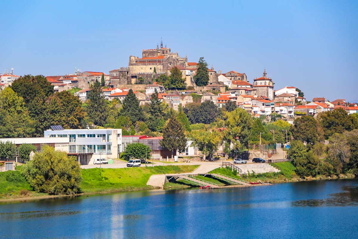
 A view of Tui Fortress from the bridge over the Minho River
Lisbon is the actual start of the Portuguese Camino though most pilgrims start their walk in Porto or Tui.
Table of Contents
Toggle
- Portuguese Camino from Tui PDFs
- Portuguese route from Tui GPX
- The Portuguese Camino from Tui route overview
- How long is the walk from Tui?
- The Compostela Certificate update in 2025
- Where in Tui does the Camino start?
- Can I walk the 100 km on the Coastal Route?
- How hard is the walk from Tui?
- Is it easy to find the way?
- Where to get the Credential in Tui?
- The Spiritual Variant, the alternative route
- The cost of the Portuguese Camino from Tui
- When is the best time for walking?
- What is the accommodation like on the route from Tui?
- How to get to Tui?
- Where to stay in Tui?
- What to pack for the walk?
- Backpack delivery service on the Camino from Tui
- Tui to Santiago de Compostela route map
- The Portuguese Camino from Tui walking stages
- Stage 1 (Stage 6 from Porto). Tui to Redondela, 31,5 km/19,5 mi
- Allternative. Tui to Redondela in 2 days
- Stage 2 (stage 7). Redondela to Pontevedra, 20,6 km/12,8 mi
- Stage 3 (stage 8). Pontevedra to Caldas de Reis, 21 km/13 mi
- Stage 4 (stage 9). Caldas de Reis to Padrón, 18,5 km/ 11,5 mi
- Stage 5 (stage 10). Padrón to Santiago de Compostela, 25,5 km/15,8 mi
- Questions or Comments?
Portuguese Camino from Tui PDFs
To make your planning easier we’ve created free downloadable PDF files that contain walking stages and places to stay on the Portuguese Camino from Tui.
Portuguese Camino from Tui walking stages PDF
Portuguese Camino from Tui places to stay PDF
Portuguese route from Tui GPX
Follow our detailed guide on How to use Stingy Nomads GPX files to navigate with your phone.
The Portuguese Camino from Tui route overview
- Distance – 117 km/72,7 mi
- Number of days – 5-7 days
- Accumulated ascent (over 5 days) – 1954 m
- Accumulated descent (over 5 days) – 1709 m
- Walking surface – 83,5 km/51,8 mi – asphalt/tar, 32,5 km/20,2 mi – gravel road/footpath
- Average cost – from 30 euros per person per day
- Route marking – yellow shells and arrows, stone distance poles
How long is the walk from Tui?
It is 117 km/74 mi from Tui to Santiago de Compostela. Despite the distance being a bit longer Tui is the most popular starting point of the last 100 km on the Portuguese Camino. Depending on your daily distances, it takes 5 to 7 days to complete the route.
If you want to walk exactly 100 km/62 mi (not 117 km) you can start in Porriño. It’s a town 103 km from Santiago de Compostela, so you reduce your walk by 14 km.
The Compostela Certificate update in 2025
From this year you don’t have to walk the last 100 km to Santiago to get the Compostela certificate. The new rule is a bit complicated if applied to the Portuguese Camino.
To get the Compostela for completing the 100 km on the Portuguese Camino you are required
- To walk at least 100 km/62 mi on any recognized Camino route. The Portuguese Camino qualifies for this.
- 70 km/42 mi out of 100 km/62 mi should be walked in Spain. For the Portuguese Camino it means you have to walk 70 km/42 mi somewhere between Tui and Santiago.
- To walk at least the last stage to Santiago de Compostela. Whichever Camino de Santiago you walk you have to walk the last stage on it to Santiago. For the Portuguese Camino it’s the Padron to Santiago stage.
- To get 2 stamps per day for every day of the walk.
In my opinion for the Portuguese Camino it’s still makes sense to start the walk in Tui since most of it (70 km/42 mi) you have to walk in the part between Tui and Santiago. For the Camino routes that mostly go through Spain you can walk any sections and the last stage to Santiago to get the total of 100 km/62 mi.
Where in Tui does the Camino start?
You can start from the Cathedral de Santa Maria de Tui, San Fernando Square. There are yellow arrows indicating the way. Before walking, you can stamp your Credential (a pilgrim’s passport) at the Cathedral.

 The Cathedral of Santa Maria is the beginning of the Portuguese Camino from Tui
Can I walk the 100 km on the Coastal Route?
Yes, it’s possible to walk the 100 km to Santiago following the Coastal Route of the Portuguese Camino. In that case, you start your walk in Vigo, a Spanish city on the Coastal Route which is exactly 100 km/62 mi from Santiago. The route from Vigo to Santiago is 19 km shorter than from Tui.
The difference between the last 100 km on the Coastal vs the Central Route is one stage. The first stage; Vigo – Redondela on the Coastal Route and Tui – Redondela on the Central Route is different. Both routes merge in Redondela and continue to Santiago following the same trail.
How hard is the walk from Tui?
The Camino from Tui is a challenging walk like any other long-distance route especially for people who have never done long-distance walking before. There are hilly parts on the route particularly the part between Porriño and Redondela and the last stage from Padrón to Santiago.
My advice is to take it easy, walk shorter distances, and stop every couple of hours for rest, coffee, etc. You don’t have to follow the standard itinerary you can break the last 100 km into 7 or even 10 stages whichever works best for you.
Is it easy to find the way?
Yes, it’s easy to find the Camino route. The stretch between Tui and Santiago is well-marked with yellow arrows painted on the ground, walls, trees, rocks, etc. In Galicia, they put small stone poles with distances left to Santiago. It doesn’t just mark the route but gives you an idea of how far you’ve already walked and how far you still have to go.

 One of the stone signs with a distance on the Portuguese Camino just outside Tui
Where to get the Credential in Tui?
If you start in Tui you can get your Credential or Pilgrim’s Passport at the Cathedral, Plaza San Fernando, around the corner from the public Albergue. It costs 2 euros. The Credential is a small paper book for collecting stamps along the Camino route. Every pilgrim needs it to stay in public albergues and to get the Compostela certificate at the end of the Camino in Santiago.
The Spiritual Variant, the alternative route
If you want to add some mountain and coastal scenery to the Camino from Tui you can walk the Spiritual Variant. It’s an alternative route of the Portuguese Camino that takes pilgrims to the coast and offers spectacular scenery. On the way, you get to visit the small charming town of Combarro, one of our favorite towns on the Portuguese Camino.
The Spiritual route consists of 2 walking days and 1 day on a boat. The route splits in Pontevedra (3 km outside the town) and merges with the main Portuguese Camino in Pontecesures. It’s a challenging trail due to a steep ascent on the first day and a steep descent on the second day.
You can find more information in our detailed post on the Spiritual Variant.
The cost of the Portuguese Camino from Tui
How much you spend on the Camino depends on several factors. You can walk it on a tight budget if you stay in albergues, cook for yourself, and carry your backpack. In this case, you can expect to spend 20 euros per day on average.
If you stay in private rooms, eat in restaurants, and use a luggage delivery service your daily expenses will be around 60 euros per person per day.
The cost of accommodation on the Camino from Tui
- Public albergues – 10 euros per person on average
- Private albergues – 15-20 euros per person on average
- Private rooms – from 30 euros per person (for a double room), from 35 euros per person (for a single room)
The cost of food
- Food shopping – 8-10 euros per person per day
- Breakfast in a cafe – 3-5 euros
- A set lunch (Menu del Peregrino) – 10-12 euros
- Dinner at a restaurant – from 15 euros per person
Extras
- Luggage delivery – 7 euros per backpack/suitcase per stage
- Laundry – 4-5 euros per load
When is the best time for walking?
Weatherwise May, June, and September-mid-October are the best months for walking the Portuguese Camino from Tui. May and September are the most popular months on the Camino.
If you want to walk the Camino in summer, escape crowds, and don’t mind the heat then July and August are the good months. These are the peak holiday months in Europe but not on the Camino.
In the second half of April, the weather is usually sunny and warm.
Winter months from the second half of October to March are quite rainy and chilly. There are very few pilgrims on the route and some albergues close for the off-season.

 Capela (chapel) de Misericordia in Tui near to the Cathedral and public Albergue
What is the accommodation like on the route from Tui?
There are plenty of places to stay along the last 100 km of the Portuguese Camino. One can find anything from public albergues (the most budget accommodation) to private Albergue/hostels and hotels. Where to stay depends on your budget and preference.
Albergues
If you’re on a tight budget public or municipal Albergues are your best option. The average cost is 10 euros per bed in a dormitory. Private albergues are a bit more expensive but usually have better facilities and are smaller. Expect to pay 15-20 euros per bed on average. Albergues have dormitory rooms with bunk beds (usually), a shared bathroom, and a common kitchen. A kitchen is great if you’re on a special diet or want to save money on eating out.
Private accommodation
Private rooms in hotels are more expensive. Expect to pay 30 euros per person for double occupancy and 35+ euros per person for single occupancy.
There are some rental apartments and even houses along the route. If you’re a family or a group of people walking together it might be a good alternative.

 A bridge over the River Minho that connects Portugal (Valença) and Spain (Tui)
How to get to Tui?
The two nearest airports are in Vigo 28 km from Tui and Porto 120 km from Tui. You can fly to any of these cities depending on where you coming from. From both places, you can get to Tui by bus and/or train.
Getting to Tui from Vigo
Vigo International Airport is the nearest airport to Tui. It operates direct flights from Barcelona, Madrid, and London. You can get to Vigo with one connection from several European cities.
You can get to Tui from Vigo by direct bus or train. Vigo bus station and Vigo Urzáiz train station are located next to each other. There are many buses from Vigo to Tui and two daily trains. Tickets can be purchased at the stations (2,5 euros – bus, 4 euros – train). It takes 1 hour by bus and 45 minutes by train to get from Vigo to Tui.
Getting to Tui from Porto
If you come from outside of Europe flying to Porto is the best option. It has a big international airport.
There are more transport options from Porto to Valença do Minho, a Portuguese town on the opposite side of the river, across the bridge from Tui. The distance between the two towns is about 1,5 km. You can walk or take a taxi. When checking for buses and trains put your destination Valença if you can’t find anything to Tui.
You can get from Porto to Valença do Minho/Tui by bus or train. There are direct buses from Porto Airport to Valença do Minho/Tui. You can find the timetable and buy tickets online. It might be the easiest option if you don’t have much time and want to start walking the Camino as soon as you land. The journey from Porto Airport to Tui takes 1h45min. The price is 19 euros.
There are direct buses from the city of Porto to Valença.
Direct trains to Valença leave from Porto Campanha train station. The journey takes 2-2h30min. Tickets are between 11-15 euros. Find more information online.
How to get from Tui to O Porriño?
If you decide to start your walk in O Porriño you can get there by bus from Tui. Daily buses leave from Tui (Praza de Galicia) regularly (every 30 minutes to 1 hour). The journey takes 20-30 minutes depending on the route. The ticket costs 1,5 euros, paid on the bus.
The best stop to get off in O Porriño is Ponte Galo (Avenida Galicia). Continue on the Avenida Galicia (in the same direction as the bus) till you get to the roundabout (the Chapel da Nossa Senhora da Angustias). From there you will start seeing the Camino signs.
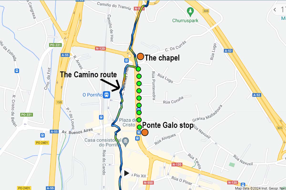
 A map of the Camino route in O Porriño and how to get there from the Ponto Galo bus stop
Where to stay in Tui?
What to pack for the walk?
Below you can find some of the most important items to pack for the Camino. More packing tips can be found in our Camino de Santiago packing post.
The most important item to pack for the Camino is shoes. Which shoes to choose depends on your preferences. We like walking the Camino in light hiking shoes. Some prefer running shoes or sneakers. The important thing about your shoes is that they have to be worn. You can find more recommendations on footwear in our post on the best shoes for the Camino de Santiago.
A backpack is another important Camino item if you plan to carry it yourself. Don’t buy a big backpack because you’ll end up filling it with unnecessary stuff. From our experience, a 30-35L backpack should be enough for a 5-6-day walk on the Camino. Find more information in our detailed post on the best backpacks for the Camino.
Merino wool socks are something that we always use when hiking. In our experience, these socks are the best for long walks in any weather. They don’t absorb odors, help to prevent blisters and dry very quickly. We have a detailed post on the socks for the Camino.

 A traditional Camino sign with the distance to Santiago on the Portuguese route
Backpack delivery service on the Camino from Tui
Several companies offer luggage delivery service on the Portuguese Camino from Tui. Your luggage is delivered every day to your accommodation place. You can walk the Camino with a daypack and the rest of your luggage will be transferred by car. The average price is 7 euros per backpack/suitcase per stage. TuiTrans, Pilbeo, and Correos are the main companies offering luggage delivery on the route from Tui.
Tui to Santiago de Compostela route map

 Walking stages of the Portuguese Camino from Tui
The Portuguese Camino from Tui walking stages
Stage 1 (Stage 6 from Porto). Tui to Redondela, 31,5 km/19,5 mi
- Distance – 31,5 km/19,5 mi
- Time – 7-8 hours (moving time)
- Ascent – 445 m
- Descent – 477 m
- Walking surface – 27 km/17,3 mi – asphalt, 4,5 km/2,7 mi – gravel/footpath
- Walking on the road – 2 km/1,2 mi
Another long and challenging day on the Central Route of the Portuguese Camino that you can split into two stages: Tui to Porriño – 15,5 km/9,6 mi and Porriño to Redondela – 16 km/10 mi.
It’s important to remember that to get your Compostela certificate after completing the Portuguese Camino route you have to collect a minimum of 2 stamps per day for the last 100 km. It’s not difficult to do one stamp you can at the place you stay and the second at a bar/restaurant along the route, most places have stamps. Usually, you don’t have to order anything to get a stamp.

 Elevation profile of the walk from Tui to Redondela
Challenges
- A long walking day of over 30 km
- Walking through a large industrial area with many factories between 9,5 km and 13,5 km
- Walking next to a busy road between 13,5 km and 15,5 km
- At 18 km there is a dangerous road crossing. It’s a busy road with no traffic light or pedestrian crossing you have to run across the road.
- A steep ascent between 21 km and 25,5 km, over 170 m up
- A steep descent between 25,5 km and 29 km, over 170 m down
Highlights
- Walking through the forest at the beginning of the day.
- The picturesque town of Mos.
- Walking through the forest in the last part of the day.
- The historical center of Redondela.
Stage 1(stage 6). Route description
The first 3 km/1,8 mi are through the town, fields, and forest.
3,3-5,3 km/2-3,2 mi on/along the road
6,8 km/4,2 mi – guesthouse Clarevar, cafe Ultreia
7 km/4,3 mi – guesthouse Casa Celia
8,7 km/5,4 mi – a route split. Make sure to take the alternative route it goes through the natural area. The main route goes through a vast industrial area.
9,2 km/5,7 mi – Albergue/guesthouse Casa Alternativo
9,5-13,5 km/5,9-8,3 mi – a big industrial area with many factories and storage facilities
13,5 km/8,3 mi – a restaurant
13,5-15,5 km/8,3-9,6 mi – walking next to a busy road
14,5 km/9 mi – a restaurant, a bar (bars in Spain are like cafes/restaurants they serve meals)
15-17 km/9,3-10,5 mi – Porriño, a town with many restaurants, shops, guesthouses, and a couple of private albergues
18 km/11 mi – a dangerous road crossing
19,5 km/12 mi – Veigadaña, a Municipal Albergue and a bar
21,3 km/13,2 mi – a vending machine with cool drinks and snacks
22 km/13,6 mi – the small town of Mos. If you’re thinking of stopping earlier it’s a perfect place. There is an albergue, a couple of bars, a restaurant, and a chapel. The long and steep ascent starts from the town.
22-25,5 km/13,6-15,8 mi – a steep ascent through the forest
25,5-28 km/15,8-17,3 mi – a descent through the forest
26,7 km/16,5 mi – a cafe
27,1 km/16,8 mi – a bar
28-29 km/17,3-18 mi – a very steep descent, 120 m down over 1 km
28,6 km/17,7 mi – Albergue/bar Corisco
31,5 km/19,5 mi – Redondela. Here the Coastal Route and the Litoral Way merge with the Central Route.
Places to stay in Redondela

 Beautiful forest scenery on the way to Porriño just outside Tui
Allternative. Tui to Redondela in 2 days
Tui to Porriño, 15,5 km/9,3 mi
- Distance – 15,5 km/9,3 mi
- Time – 3-4 hours (moving time)
- Ascent – 171 m
- Descent – 185 m
- Walking surface – 12,5 km/7,7 mi – asphalt, 3 km/1,8 mi – gravel/footpath
- Walking on the road – 2 km/1,2 mi
Places to stay in Porriño
Porriño to Redondela, 16 km/10 mi
- Distance – 16 km/10 mi
- Time – 3-4 hours (moving time)
- Ascent – 274 m
- Descent – 292 m
- Walking surface – 14,5 km/9 mi – asphalt, 1,5 km/0,9 mi – gravel/footpath

 The historical center of Tui, Spain
Stage 2 (stage 7). Redondela to Pontevedra, 20,6 km/12,8 mi
- Distance – 20,6 km/12,8 mi
- Time – 4-5 hours (moving time)
- Ascent – 425 m
- Descent – 400 m
- Walking surface – 13 km/7,4 mi – asphalt, 7,5 km/4,6 mi – footpath/gravel
- Walking on the road – 500 m/0,3 mi
It was a pleasant walking day with beautiful forest scenery and many places to stop for coffee and rest including several spontaneous stalls in the middle of the forest where you can get snacks, coffee, cool drinks, and a stamp leaving a donation.

 Elevation profile of the Camino route from Redondela to Pontevedra
Challenges
- A steep ascent between 1,7 km and 4,7 km, around 140 m up
- A steep and short descent between 4,7 km and 6 km, around 100 m down
- Another steep ascent between 10 km and 12 km, around 130 m up
Highlights
- Walking through a beautiful forest throughout the day
- The Medieval Bridge de Pontesanpaio over the River Verdugo with spectacular views
- The historical center of Pontevedra

 The Medieval Bridge of Pontesanpaio and its spectacular surroundings
Stage 2 (stage 7) route description
The first 4 km/2,4 mi are through a quiet countryside
2 km/1,2 mi Cesantes, a town with a private Albergue
4-5,5 km/2,4-3,4 mi the route goes through the forest
6,5-9,6 km/4-6 mi – walking through several towns with several albergues, hotels, restaurants, and shops.
8,6 km/5,3 mi – Medieval Bridge de Pontesanpaio. It’s a beautiful bridge with spectacular views. It’s a good place to stop for lunch or coffee. There are a couple of cafes and bakeries before the bridge.
9,6-11,6 km/6-7,2 mi – walking on a footpath through the forest
15,5 km/9,6 mi – a bar, a shop, and a small chapel where you can get a stamp
15,8 km/9,8 mi – a split on the Central Route. Most people take the complementary route because it goes through the forest instead of the “official” route along the road.
16-19 km/10-11,8 mi – walking on the footpath through the forest
19 km/11,8 mi – an albergue/cafe
19,5 km/12,1 mi – the outskirts of Pontevedra
20,6 km/12,8 mi – the historical center of Pontevedra
Places to stay in Pontevedra

 The historical center of Pontevedra
Stage 3 (stage 8). Pontevedra to Caldas de Reis, 21 km/13 mi
- Distance – 21 km/13 mi
- Time – 4-5 hours (moving time)
- Ascent – 275 m
- Descent – 270 m
- Walking surface – 12 km/7,4 mi – asphalt, 9 km/5,6 mi – footpath/gravel
- Walking on the road – 0 km, 1 km on a footpath along the road
It’s an easy walking day without strenuous ascents or descents. In the first half there aren’t any places to stop for food or coffee it’s better to have breakfast in Pontevedra before starting the walk. In the second half after 9 km, there are cafes and bars. Caldas de Reis is s small town a lot smaller than Pontevedra. It has many hotels, albergues and restaurants, and a couple of supermarkets.

 Elevation profile of the Camino route from Pontevedra to Caldas de Reis
Challenges
- No places to stop for food/coffee for the first 9 km
- 12 km/7,4 mi walking on tar (asphalt)
Highlights
- The beautiful forest between 6 and 9 km and between 16 km and 19 km
- The charming historical center of Caldas de Reis
Stage 3 (stage 8) route description
0-1,4 km/0-0,8 mi – walking through the city
3 km/1,8 mi – the route split; the left route is the optional route Variante Espiritual (Spiritual Variant) and the right route is the main Portuguese Camino route. The split is well-marked.
6,5 km/4 mi – a 60 km sign
6-9 km/4-5,5 mi – through the forest

 The forest scenery on the last 100 km from Tui is spectacular
9 km/5,5 mi – cafe Pousada Peregrino
9,5 km/5,9 mi – Portela, private Albergue, 200 m away from the Camino (follow the signs)
9,5-10,5 km/5,9-6,5 mi – next to the road
11,5 km/7,1 mi – a vending machine and a bar
12-14,5 km/7,4-9 mi – through the forest
15 km/9,3 mi – a couple of cafes/bars
16,5 km/10,2 mi – Briallos, a public Albergue, 300 m from the Camino route (follow the signs).
18 km/11 mi – a cafe
19,5 km/12 mi – Tivo, Albergue/bar Vintecatro
21 km/13 mi – Caldas de Reis
Places to stay in Caldas de Reis

 Church of Santo Tome Becket in Caldas de Reis
Stage 4 (stage 9). Caldas de Reis to Padrón, 18,5 km/ 11,5 mi
- Distance – 18,5 km/11,5 mi
- Time – 4-5 hours (moving time)
- Ascent – 283 m
- Descent – 296 m
- Walking surface – 11 km/6,8 mi – asphalt, 7,5 km/4,6 mi – footpath/gravel
- Walking on the road – 0 km
It’s a short and easy walking day with beautiful forest scenery. The forest part of this stage is one of my favorites on the Camino from Tui. Many pilgrims prefer not to stay in Padron and walk to one of the albergues/hotels to shorten their last walking day. It is a good idea and there are several places between Padron and Santiago where you can stop.

 Elevation profile of the route from Caldas de Reis to Padron
Challenges
- An easy walking day on the Camino.
Highlights
- The picturesque Galician forest with small waterfalls, rivers, and rest areas.
- A beautiful church at 5,8 km/3,6 mi
- The historical center of Padron
Stage 4 (Stage 9) route description
2-5,2 km/1,2-3,2 mi – walking through the forest
5 km/3,1 mi – a 40 km to Santiago sign
5,4 km/3,3 mi – bar Parillada Antonio and guesthouse Pension Sevi 20 m from the Camino route after crossing the road
5,8 km/3,6 mi – the beautiful church of Santa Mariña de Carracedo with a wooden statue of a shoe

 The church of Santa Mariña de Carracedo on the Camino route between Caldas de Reis and Padron
7 km/4,3 mi – a busy road crossing without a traffic light or pedestrian crossing
7,2 km/4,4 mi – a cafe
7,6 km/4,7 mi – a small sculpture of a pilgrim on the top of a pillar
8,5 km/5,2 mi – a bar
9,6 km/5,9 mi – Municipal Albergue de Valga, 300 m from the Camino follow the signs
9,8 km/6 mi – a rest area in the forest
10-11,5 km/6,2-7,1 mi – walking through the beautiful forest
12 km/7,4 mi – San Miguel de Valga, a cafe and a restaurant
14,6 km/9 mi – a rest area
15,5 km/9,6 mi – a drinking fountain (there are several fountains along the Camino route but I’d recommend drinking only from those that have a sign “Agua potable” which means drinking water in Spanish.
15,6 km/9,6 mi – a small coffee stall
16,3 km/10 mi – guesthouse Casa do Horreo
16,5 km/10,2 mi – Pontecesures, a small town
18,5 km/11,5 mi – the center of Padron (there are several albergues on the way from Pontecesures to Padron)
Places to stay in Padron
Casa de Marcelo is our special recommendation for a place to stay near Padron. It’s a small guesthouse (4 rooms only) in the mountains near Padron where we stayed for 3 nights. The guesthouse is beautiful, located in a quiet area, a perfect place to rest on the Camino. The owners are friendly locals who can arrange a pick-up for you (or you can take a taxi from Padron for 5 euros), make dinner and breakfast, and even treat your blisters.

 Paseo del Espolon, a promenade along the river in Padron
Stage 5 (stage 10). Padrón to Santiago de Compostela, 25,5 km/15,8 mi
- Distance – 25,5 km/15,8 mi
- Time – 6-7 hours (moving time)
- Ascent – 526 m
- Descent – 266 m
- Walking surface – 20,5 km/12,8 mi – asphalt, 5 km/3,1 mi – footpath/gravel
- Walking on the road – 600 m on a quiet road
It’s a challenging day due to the distance and steep ascents in the last part of it. If you walk during the high season expect to see many people. The scenery on the last day is very diverse from walking next to a busy road to going through a quiet forest and countryside.
Many people split the day into two to make their last day shorter. There are plenty of places to stay in the second half of the day. E.g. the town of Milladoiro which is 7 km before Santiago.

 Elevation profile of the last stage of the Camino from Tui, Padron to Santiago
Challenges
- Several ascents in the second half of the stage, the accumulated ascent for the day is over 500 m.
- Relatively long distance, over 25 km
Highlights
- The beautiful Galician forest
- The historical center of Santiago de Compostela
- Arriving at Obradoiro Square and seeing the Cathedral and hundreds of other pilgrims

 A distance sign in the forest on the Camino route indicating how far Santiago de Compostela
Stage 5 (Stage 10) route description
2-3 km/1,2-1,8 mi – along a busy road
2,2 km/1,3 mi – a restaurant, a cafe
2,7 km/1,6 mi – hotel Scala, restaurant
3-4 km/1,8-2,4 mi – walking through small villages
5,5 km/4,3 mi – albergue O Lagar de Jesus. It might be a good place to stop if you want to walk further on instead of staying in Padron the previous day.
6,2 km/3,8 mi – A Escravitude, a small town with a beautiful church, restaurants, bars, and hotels. It’s another good place to walk from Caldas de Reis instead of Padron.
8,9 km/5,5 mi – a rest area
9 km/5,5 mi – Guesthouse Areal
9,5 km/5,9 mi – Picaraña, a couple of guesthouses and restaurants
10-11 km/6,2-6,8 mi – the beautiful forest
11 km/6,8 mi – O Faramello, a cafe, a restaurant, Municipal Albergue de Faramello (150 m from the Camino)
11,2 km/6,9 mi – Albergue/bar La Calabaza del Peregrino
12 km/7,4 mi – a bar
12,4 km/7,7 mi – Hotel/restaurant Parada de Francos
13,8 km/8,5 mi – Cafe/shop
14,2 km/8,8 mi – Pedreira, Albergue/cafe de Pedreira
17,6 km/10,9 mi – Milladoiro, a town with restaurants, cafes, supermarkets, and hotels. It is a good stop for those who want to split the last day into two stages.
20,5 km/12,7 mi – Parador La Roda, cafe & souvenir shop
23 km/14,2 mi – a route split
24 km/14,9 mi – Santiago de Compostela
25,5 km/15,8 mi – Obradoiro Square and the Cathedral
Places to stay in Santiago

 The Cathedral of Santiago de Compostela and Obradoiro Square is the end of the Portuguese Camino from Tui
Questions or Comments?
Got any questions or comments? We would love to help! All questions and comments will be answered by us personally in Buy Me a Coffee. Click below and ask away.
Feel free to support our site by buying us a coffee!


The pretty half of Stingy Nomads, responsible for all our land adventures (hiking, climbing, walking the Camino) and following them write-ups. Alya loves walking since she was a child, she prefers to walk 1000 km with a backpack rather than to do a 10 000 km road trip (actually any road trip). Alya is a big fan of Latin America, the Spanish language, and dancing. Every time we go away she desperately misses our dog Chile.
Please visit:
Our Sponsor